I stopped at Box Canyon to use the restroom and on a whim decided to jump the low fence to check out the view downstream from an exposed granite outcropping, hoping it to be better than from the official viewpoint. It was a nice overlook for the debris slope leading down to the river and the forest beyond, but nothing of the river itself. I could see what looked like a relatively easy path down the talus closer to the river and decided to try it. It was precarious in parts, and I am far from surefooted, but I eventually made it down the slope to the river edge itself.
There was a mass of whitened driftwood logs from the floods at a bend in the river, and the sandy shore was volcanic gray. Climbing over the mass of logs onto the boulders jutting from the river, I found the view I had always speculated about -- the view up the narrow canyon from the river. While it was nice, it wasn't the view I had imagined, but still I kicked myself for not bringing my camera and at least documenting the view. The climb back up to the parking lot was much harder than it looked, particularly in the hot sun without having eaten lunch, and I had to stop to rest several times.
In the bright midday sun, I decided to head out of the park and scout for views of Rainier from the southeast. I ended up across US-12 south of Packwood, in the FS-46 road network on the side of Coal Creek Bluff. There were some decent views from clearings on the switchbacks up FS-4612, even if they were rather far away, but clouds were now blanketing the mountain enough that I couldn't quite place it on the horizon. I tried to do some impromptu creek hunting along FS-410 along Coal Creek despite the sun, but the road abruptly washed out at the first major tributary. Another victim of the floods.
Scouring the map for a closer viewpoint, I settled on Laurel Hill, back on the northern side of US-12, just outside the southeast corner of the park. The most promising road was an offshoot of FS-4510 up the face of the hill, but once on the road I realized that Backbone Ridge was too near and too tall, blocking most of the view. Deep ruts in the road from the winter floods prevented me from making it to the end, but by then I already had another destination in mind.
The main road up Cortright Creek (FS-45) circled around behind Laurel Hill and climbed to the top, termiating near its summit on the map. It was a long drive, and flood damage was very evident in two areas of slumped hillside that had been cleared from the road. It wasn't until I made it farther up the road that I realized it was the road itself that had slumped, taking out half the road in two different spots. Fortuantely they were still safely passable, but any more slumping and it won't be. The trailhead for the Cortright River Trail is beyond them so there is hope they will get fixed. I stopped at the trailhead for a moment, but I was unable to find the trail, even with a delapidated trailhead sihn pointing me in the right direction.
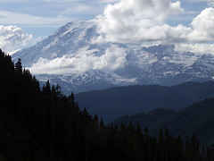 Continuing on toward the end of the road finally brought me to the views I'd sought. There are several points along the latter part of FS-45 that are clearcut and open up to views into the park of both Rainier and Little Tahoma. The clouds had begun to break, so I was able to grab snapshots enough to document the area. There are plenty of place to camp, so this could prove to be an excellent destination for sunrise photos. I dutifully documented the view from each of the viewpoints from the road fork to the end of the road, and even explored the lower fork enough to realize the good views from were above.
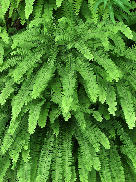 I drove back along Stevens Canyon Road on my way back, as the sun was setting behind the clouds that still huddled around the mountain. This gave me the cloudy conditions needed to photograph a roadside cliff face decorated with maiden hair fern I'd noticed several times over the last few years, but had never bothered to stop. These turned out to be my only serious attempt at photography for the day, but they only turned out mediocre. Even though I knew there were good shots there, I just couldn't seem to find them.

No comments:
Post a Comment