November 17, 2006

MRNP Flood Damage

Not to keep harping on this but the flood damage is so devastating, particularly at Mount Rainier National Park. This has already become the wettest November on record for Seattle, and is very close to becoming the wettest of any month at all. And there's more storms coming.

These photos are from the National Park Service for MRNP. I am very glad that I spent so much time there this fall, because it may be a year before some of these roads are open again.

Eastside Road (SR-123):

Eastside Road Washout
Eastside Road Landslide


Grove of the Patriarchs:

Suspension Bridge Damage
Damaged Boardwalk in Mud


Ohanapecosh:

Destroyed Picnic Table in Ohanapecosh Campground
Logjam on Ohanapecosh River


Carbon River:

Carbon River Road Washout
Ipsut Cabin Washout
Ipsut Cabin in Mud


Nisqually:

Longmire Road Washout
Longmire Road at Former Site of Sunshine Point Campground
Longmire Road Washout


SR-410:

Flooding on SR-410
Flooding and Downed Trees on SR-410

November 15, 2006

More Flood Damage

More photos from the flood damage of the last week. Again, I do not take credit for any of these photos.

Grove of the Patriarchs, MRNP (from Mount Rainier Climbing and Pütz-in-Boots @ NWHikers):

Interpretive Sign in MudDamaged Suspension Bridge


Carbon River Road, MRNP - 2 miles of road washed away (from Tazz @ NWHikers):

Carbon River Road Washout


Index, WA (from andrew e @ NWHikers):

Index-Galena Road Washout


FS-74 / West Fork White River, MBSNF (from Justan @ NWHikers):

FS-74 Washout


Suiattle River Road, MBSNF (from Quark @ NWHikers):

Suiattle River Road, First Washout
Suiattle River Road, Second Washout

November 07, 2006

Floodwaters

When I was watching the high water levels last weekend, I had no idea what was in store for the area. Western Washington has been in what could be 100 year floods. Almost every major road into the mountains is closed from flooding, possibly permanently. Most of the major rivers are at or beyond record heights. Entire towns have been evacuated and are under water. The Sunshine Point Campground at Mount Rainier National Park has completely washed away -- it is no more -- along with a quarter mile of the Longmore Road. The power of Nature is simply incredible.

The following are selected photos from the floods. I did not take these pictures, and do not take credit for them in any way.

Deception Falls NRA (from Alpine Andy @ WTA):

Footbridge Over Deception Creek Flood
Deception Creek Flood


Snoqualmie Falls (from MtnDog @ NWHikers):

Snoqualmie Falls at Flood Levels


Mount Rainier National Park (from Mount Rainier Climbing):

Longmire Road Washout
Longmire Road Flooding
Westside Road Flooding


Stillaguamish River (from JimK @ NWHikers):

Stillaguamish River Flood


Fall City, WA (from MtnDog @ NWHikers):

Snoqualmie River Flood


Snohomish River (from Pütz-in-Boots @ NWHikers):

Snohomish River Flood


Middle Fork Snoqualmie River (from Tom @ NWHikers):

MFK Snoqualmie Flood


Granite Falls, WA (from naturalbeing @ NWHikers):

Granite Falls Fish Ladder Flooding


Eagle Falls (from Seattle Times):

Eagle Falls Flooding


North Fork Skykomish River (from kleet @ NWHikers):

NFK Skykomish River Flooding


Nooksack River (from Bellingham Herald):

Nooksack River Flooding at I-5


Cowlitz River (from grizzly86 @ NWHikers):

House Floating Down a Flooded Cowlitz River

November 04, 2006

When It Rains

Despite the predicted wind and heavy rain, I decided to retrace my steps from last weekend. There were several places I wasn't able to shoot because of fading light or falling snow, and I didn't think I'd get too many more weekends this year to attempt them.

The drive along the Index-Galena Road was a precursor of what was in store for the day. The prevalent maple leaves scattered on the ground that were so beautiful and yellow last weekend were now dingy brown and soaking wet, and the rivers and creeks were running much higher thanks to the rain we've had this week.

I made it to the Quartz Creek trailhead despite the quarter inch of snow on the road and quickly saw that the primary photos I was after for the day were impossible. What had been a majestic and graceful cascade on the North Fork Skykomish River was now a raging torrent.

I again drove up and over Jack Pass down into the Beckler River valley, the frozen rain replaced this time with a driving downpour. All the tiny runoff streams were full and even the normally dry creek beds were running. Places like Fourth of July Creek had filled or were overflowing their banks and looked nothing like they had the previous weeks.

The small stream covered with maple leaves that I'd photographed last week was much less photogenic this time, so I drove back up Rapid River Road to see how the cascade at the end looked in this weather. I certainly didn't expect it to look anything like last time. The fresh and falling snow on such a majestic waterfall was certainly not to be repeated this time, and I was right. I tromped around in the forest, looking for the canyon I'd heard about, until I was too wet and cold and had to turn back.

That was it for the day, there was nothing left to see. The weather was too ugly and the water too high for me to get the camera out even once.incredible.

October 29, 2006

First Snow at Rapid River

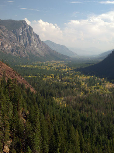
Now that fall color was pretty much over for the year, my thoughts switched to mushrooms. I'd never really focused on mushrooms before, although I had taken the occasional photo, but the specimens I'd seen the last few weekends had inspired me. I thought back to where I'd seen the best mushroom displays in previous years, and of the handful of places that came to mind -- Lake Elizabeth, Money Creek Road, Asahel Curtis -- the best I remembered was on the Quartz Creek Trail. So this was to be my destination for the day.

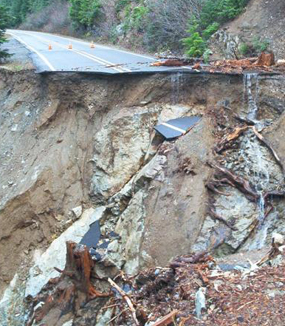
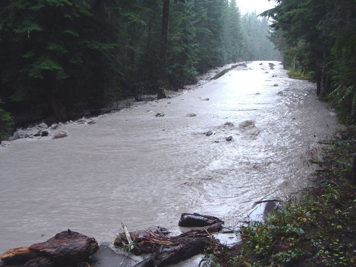
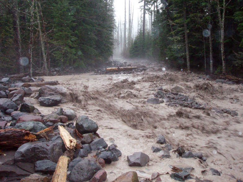
The trailhead was deeper in the forest than I remembered, but while the drive took longer than I anticipated, it gave me the opportunity to see the Index area in post-Autumn color. The Index-Galena Road was literally covered in fallen maple leaves at some points, and all of the creeks and rivers in the area had significant flows. I considered stopping for photos, but I stayed focused on Quartz Creek. How many times can I shoot Bitter Creek?

A light rain fell as I drove along the Forest Service roads, but the mountain tops and high elevation trees had a fresh dusting of snow. I didn't expect to see any snow myself, but on that I was quite wrong. About a quarter mile from the trailhead there was snow beside the road, and a steady light freezing rain fell once there. I decided to start the hike anyway, since the weather was supposed to clear for the afternoon, which wasn't far off now.

The Quartz Creek Trail is pretty flat, following near Quartz Creek for 4 miles or so, and entering the Henry M. Jackson Wilderness about a half mile in. The creek looks rather photogenic in places, but there's no point that I remember where the trail actually touches it, and the scramble down seemed treacherous even without snow. But that was not why I was there. Unfortunately, the mushrooms I remembered before were nowhere to be seen. Perhaps they were covered by the thin layer of snow, or maybe it was the wrong time of the season. Either way, the plan seemed a bust.

After about a mile, with the snow thicker and the sleeting heavier, I began to question the wisdom of continuing on. I was not equipped for this type of travel -- particularly my shoes -- and thought I should probably turn back. Accidents in even light winter conditions can turn south in a hurry if you aren't properly equipped, and I wasn't. My feet were already getting wet from recently discovered holes in my shoes, and in the back of my head the thought was nagging at me that I hadn't brought my snow chains. If this kept up -- even though it wasn't supposed to -- I might have trouble getting back down the road. I played "one more hill" for another half a mile, then after a short rest stop, decided to turn back.

It ultimately proved to be a wise decision, but at the time I wasn't so sure. By the time I made it back to the trailhead, the sun had broken through the clouds and the freezing rain had stopped. I was starting to regret my decision, but I wasn't going to start back out again. Instead I focused on the convergence of Quartz Creek and the North Fork Skykomish River. I had just set up for a shot of a leaf-covered dry creek bed when the sun abruptly disappeared and the bottom fell out of the dark gray clouds above me. If it had been raining, it would have been a downpour. Instead, the air was filled with what looked like pea-sized styrofoam balls. The freezing rain was so thick it made photographing impossible. It was quite a sight, and I stayed around a few minutes after reaching the car to try to capture it, but to no avail.

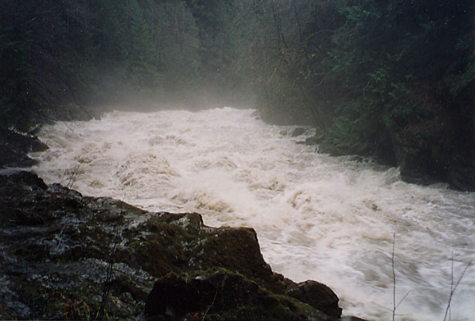
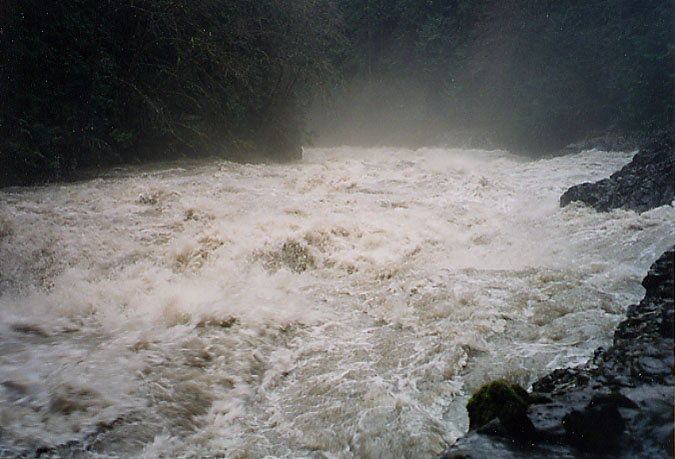
Heading back down the road, I noticed a small canyon on the NFK Skykomish that was very nice, complete with cascades and waterfalls on the lower section. I was above the canyon, the road following along the top of one rim, but there was access to a perfect front-view area for shooting the cascades and the scramble down from the road wasn't too bad. But under the current wintry conditions, shooting it would have been impossible. I considered staying there for a while to see if conditions would improve, but the sky did not look promising. I made a mental note to come back to this place and drove on.

Instead of heading back toward Index, I decided to check the conditions at Jack Pass and drop down into the Beckler River Valley on the other side, conditions allowing. There was as much sleet at the pass as there was in the Quartz Creek area, and because of the open slopes it was coming in at a dramatic angle. It was a virtual blizzard. I stopped at one point to look at the map, staying put for only a few minutes, and the car was covered in a sheet of sleet and snow in no time.

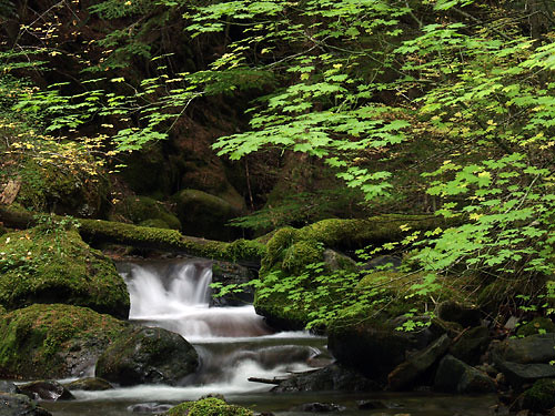
I drove down from the pass on Beckler Road and the conditions changed back to clear weather as quickly as the wintry weather had moved in. The shy was still gray, but the sun peaked through breaks in the clouds and neither rain nor sleet fell. I had pretty much given up on the day, but this renewed my hope for photos. Driving along watching the river, a small creek caught my eye. I had completely forgotten about it, a place I had photographed before. It was only really photographable when the maple leaves had fallen and the weather was wet, which made the current conditions perfect. I spent quite a while reshooting this little creek at its big mossy boulder, wondering if the photos would supplant the one already on my site.

Afterward, I was once again inspired and not quite ready to head home. I decided to backtrack up Beckler and take Rapid River Road to its end about three miles up. There were several places along the river that might have made nice photos, particularly with the alder and maple leaves decorating the rocks beside and within the river, bit for some reason I broke one of my cardinal rules. I drove on thinking I would photograph them on the way back down, instead of stopping then to shoot them. Usually bypassing a photo for later doesn't work out, which was true this time as well.

Aside from occasional views and crossings of the river and a few tributaries, the drive up the road is pretty normal. About a quarter mile from the end, however, is a wide and rock creek crossing, with many cascades and waterfalls. It's been a good place for photos in the past, and this time was even better than normal. There was fresh snow on the ground just before the crossing -- real snow this time, not frozen rain. All of the trees across the valley had a fresh dusting of pristine snow, and everything was undisturbed, like virgin country. I set up my tripod and starting shooting the cascades, wondering if I could find a good photo of the trees and valley around me.

Afterward, I drove on to the end of the road and parked so I could scan the river for photos. The view from the small unofficial campsite is nice but not really photogenic, but there was one other place I wanted to check. Earlier in the year I had found a small footpath that headed downstream toward the river, but the vegetation was so thick that I decided not to try to follow it. The roar of the river was close, meaning there was probably a cascade or waterfall near the end, but it was too dangerous to continue on without being able to see ahead. This time however, the vegetation had lost most of its leaves and the trail was very easily to follow.

I descended through the brush and snow for about 100 feet to the river's edge and turned upsteam to an amazing sight. The river cut a zigzag path through boulders before falling into a deep pool surrounded by more large rocks. The trees overhanging the river and cascades were perfectly photogenic in their own right, but were covered in a fresh layer of virgin snow. The view upriver was a ghostly path through the trees, serving as a perfect background. The pool before me at the base of the falls split perfectly in two around a huge boulder and rejoined at the bottom into a single flow. It was an amazing and beautiful sight -- one of those places that, if captured just right, can become a classic photo. And then the snow started to fall.

I can hardly describe the feeling I get seeing the first snow of the year. The only term that seems to fit is magical and it's so overused to be meaningless. But the drifting flakes in front of such a beautiful scene literally left me stunned and speechless. I knew then that there was no way I would ever be able to capture what I was seeing, particularly in still images. For one of the first times in my life I wished I'd had a video camera, but even then I knew it would be a futile effort. I stopped taking pictures altogether and simply enjoyed the beauty before me. It surpassed my driving need for photos, my need for creativity. For an all too brief moment, I was sated.

I stayed as long as I dared, but the snow grew heavier and started to stick, and I reminded myself again that I didn't have chains with me. It was only this that made me finally leave. I could have stayed there forever. I wonder now if that place will ever be that beautiful again, or if I was fortunate enough to have been at the right place at the perfect moment in time.

October 13, 2006

Harts Pass

I wanted to get a taste of the upcoming larch season, and I'd heard that the Okonogan National Forest on the east side of the North Cascades was a great place for viewing, particularly in the Methow Valley. I made the long but nice drive out to Washington Pass on the North Cascades Highway and envisioned dropping down into Early Winters Valley surrounded by larches.

That turned out to not be the case. There were some scattered larches in the upper reaches of Washington Pass, around Liberty Bell and the eastern ridges, but not nearly as much as I'd expected. I still had plenty of time to drive to the Methow Valley and all the way up to Harts Pass, but I was in a loaner car while mine was in the shop, and it was not trail car -- a Toyota Carolla. I decided to give it a shot anyway. I could always turn back if the road got too bad for the car, and the first part was paved from what I remembered.

Flagg Mountain and Methow Valley, Autumn (Snapshot) The early part of the road is a standard drive through a lowland eastside forest, mostly of pines. There are a few campgrounds on the Method River that I stopped by, remembering the last time I'd been there, a few years ago, when the river was almost completely frozen and the picnic tables were covered in inches of large frost crystals. But as the road starts to gain elevation, breaks in the trees allow views over the valley and I found a nice photo that I had forgotten. Unfortunately, the sky was too hazy and the sun too bright to get anything more than snapshots. It's a shame because the trees in the valley had turned and it was a very photogenic site. I will definitely have to come back for this photo some time.

The upper valley looked like it had once been a fantastic place for viewing larches, but it had been ravaged by fire in what looked like only a few years ago. The entire valley was a matchstick forest of charred trunks and scarred ground, from ridge to ridge. It was quite an interesting site but the light was too bright to try photos. Maybe on the way down.

Other than one place where I had to be careful of fallen rocks, the road was fine all the way to Harts Pass. The pass is just a jumpoff area, however, leading to several different destinations in the upper mountains. The place I remembered best was Slate Peak. It's a zigzig drive up an open mountain side leading to a lookout tower surrounded in 360 degrees by views of the surrounding peaks and ranges. I spent several hours taking snapshots and, once the sun set more, taking photos in the area. The larches here were scattered as well, but I managed to find a few at peak color and work them into some pictures.

Point B and Larches, Autumn
Larches, Autumn


I did spend some time taking photos on the way back down the valley. The evening sunlight really made the burned forest feel ethereal, but I had a difficult time finding photos. The low angle of the sun in the ridged terrain made for a lot of shadows. One mountain in particular did stick out, so I focuesed on it and tried to make the best of it.

Point A and Burned Forest


After the valley was in shadow, I raced back to Washington Pass to see if I could catch Snagtooth Ridge bathed in the golden sunset light I'd seen the last time I was in the area, but I just missed it. The entire ridge was in shadow by the time I arrived.

October 06, 2006

Best Laid Plans

You know what they say about the best laid plans. This was to be another Rainier weekend -- three more Autumn days in and around the park -- but I only made it as far as Maple Valley before my engine light came on. I refused to turn back at that point, but I knew instantly that my three day weekend was now a single day in the mountains.

Goat Creek and Vine Maple, Autumn My first stop this time of year when going in the northeast entrance to Rainier is Goat Creek. There's a photograph there, where a vine maple hangs over a particularly photogenic mossy cascade inthe creek, that I've photographed several times before, yet I've never been able to catch it at peak fall color. So I've vowed to stop in every time I'm in the area this Autumn to see if I can catch the best color. Unfortunately, today was not quite there so I'll have to come back. But it's still a nice photo and the vine maple has begun to turn, so I snapped some photos. That is not the only pontentially good photo on the creek, however, even within the first 100 yards. I spent almost an hour along the lower creek looking for and photographing new shots.

Cascade on Goat Creek

I did a quick check along the American River valley to check on the status of the larches, but they were still wel before peak color. I'll have to focus on the later, because prime vine maple season is well upon us.

I decided to spend some time on the Grove of the Patriarchs trail, since the vine maples in the area were close to peak. I've always loved this trail, but I've never had much luck photographing it. Scale is a problem when dealing with such large trees. How do you make them look so large in the photo without some distracting element just there to show size? I spent more time this hikie photographing a pair of trees along the trail itself rather than in the grove at the end, but I think the results were promising. The colors in the grove were amazing -- a yellow wall of vine maples behind old growth trees -- but as usual at that spot, I had trouble finding good composition.

Old Growth Trees Grove of the Patriarchs Trail


Fence and Vine Maple, AutumnI ended the day in the Box Canyon area. It was cold and drizzly, but the vine maples were at peak at this higher elevation. I only had a little light left, but managed a few decent shots before heading home. I really enjoy the crossed-log fence in that area and have always tried several times to get photos of it, but have always been disappointed with the results. They came out better this time, with the constrasting red vine maple leaves and green ferns, but I didn't have enough time to quite get the picture I wanted. I know it was there, I just couldn't seem to find it.