I'd have to enter the park from the west, as the east side road is closed due to winter washouts. I left late and by early afternoon I was near the Nisqually entrance. The sky was mostly cloudless, meaning it would be a while before the sun set enough to get some evening photos, so I had time to kill. I thought I'd look for some potential vantage points for sunset photos of Rainier in the National Forest west of the park. Looking over the map, I found a road that ran along an exposed ridge line and ended at a point called Glacier View. You can't ask for better than that. Why hadn't I seen this before?
I worked my way up FS-59, hoping I'd be able to make it to the ridge before hitting snow, but rounding one of the switchbacks I hit a snowbank on the road that stopped me in my tracks. I got out and walked around the bend enough to see the snow continued up the road, and up on the ridge you could see the road I was heading for, a white line of snow. Glacier View would have to wait a few more weeks.
I also noticed that someone had apparently made a makeshift camp at the snowbank recently -- probably for Memorial Day -- and had left a tremendous amount of trash lying about, mostly bottles and cans. I had time to kill and I despise litter in the forest, so I loaded up all the trash I could easily reach into the back floorboard. Returning back down the road, I stopped at two more fire rings and picked up more trash of beer cans, bottles and used shotgun shells. I was getting rather irritated at the uncaring campers when karma presented itself, at least a little -- a waterlogged and completely unusable cell phone. A little bit of justice.
On the way back down the road, I swung down a branch road to check out the trailhead to Lake Christine. The hike looked promising for views of Rainier, so I thought I might stretch my legs a bit and scout the views. It didn't look like I'd be getting any sunset photos this day as the clouds where quickly approaching from the west, exactly as they'd predicted for once. I made it to the trailhead after driving a couple of questionable snowy areas, and the trail and most of the trailhead were a foot deep. I decided against the hike and spent some time looking at the map of the area and having some lunch.
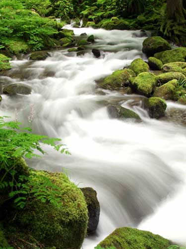 The clouds were indeed coming in fast, and by the time I made it to the crossing of Copper Creek near the beginning of the Forest Service road, the sun was completely gone. Under this new clouded light, Copper Creek really showed its glory and I stopped to investigate for photos. There was a small but well-worn footpath up the left side that I decided to follow and I really got to see how photogenic this creek was. I spent no less than an hour taking photos at several spots before heading out back toward the park. I will be interested to see what this creek looks like in the fall when the water level comes down.
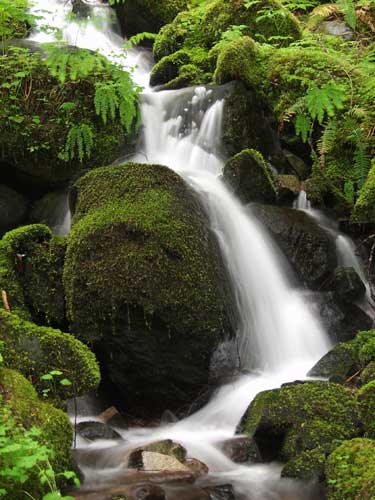 Once in the park, I emptied the trash at the recycling bins at Sunset Point. A little farther along I crossed the juntion of the West Side Road and on a whim decided to follow it. There hasn't been much along this road photographically in the past, but I had plenty of time and you never know. Indeed, you never know. Still in sight of the junction of the main road, I stopped to investigate a small runoff stream tumbling down the hillside. One section in particular caught my eye and I deemed it worth at least a few photos. A nice surprise, even if the wind was blowing a little too much to keep the vegetation still.
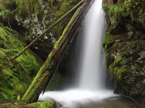 Afterward, I was driving at a pretty good clip farther up the road, expecting to soon hit the washout that had forced the closure years ago, when something caught my eye off to the left. I skidded to a stop and pulled over, and was surprised to see such a nice waterfall here. Despite driving this road several times before, I had no memory of this place at all. I looked on the map and found it was on an unnamed runoff stream from Lake Allen higher above. The waterfall didn't even have a name. I trudged through some undergrowth with the camera and tripod, after whacking down some menacing devil's club, and spent almost an hour here taking what would turn out to be my best photos of the trip.
The rest of the day was spent driving the entire length of Stevens Canyon Road. I stopped first at Christine Falls to check its recovery since the mud flows a few years ago and snapped a few photos of a stair-stepping runoff stream. By the time I reached Reflection Lakes, still under several feet of snow, Rainier was all but invisible in the clouds. Still, I stopped here for dinner since I had virtually the entire place to myself. I continued eastward, stopping occassionally at potential photos, until I reached Falls Creek, and decided to turn around there and head home.
 Falls Creek Falls has been a frustrating place for me in the past. It's a nice waterfall in the spring when the flow is high, but I've never been able to find a good photo, despite several attempts. The wind was blowing a bit too much for me to get a good one now, keeping the branches moving too much for the slow shutter speed I needed, so I played around with framing and managed to find a photo I like. Now I'll have to go back during better conditions to get a shot worthy of the falls. No matter -- I never mind another trip to Rainier.

No comments:
Post a Comment