After allowing sufficient time for the morning rush hour traffic to clear, I drove south into the thick gray clouds and hoped they would hold. The weather reports were for clearing skies in the afternoon, but it's usually a crapshoot, and today would be no exception. For the entire drive from my garage to the Gifford Pinchot National Forest, the sky was a dark and foreboding gray -- exactly what I needed. And as soon as I hit Yellowjacket Creek, where I'd left off last weekend, the clouds gave way to bright blue sky.
Southern GPNF was a wash. Looking at the northern sky, however, the giant cloud bank still clung to the mountains. I'd basically driven out from under the grey roof as I reached Yellowjacket. So I turned around and drove back north, into the northern part of GPNF between Mt Rainier National Park and US-12.
I knew I had driven some of these roads before, but I couldn't remember which ones, so I picked what looked like a good loop along several different creeks that would put me back near Mt Rainier afterward, so I could drive up the east side for a easier route home.
I started off heading north on FS-47 out of Packwood and was rather disappointed at the creek crossings there. Several of the more promising spur roads were undrivable, and the ones I could navigate were uninspiring. I had planned to branch off on FS-5240 to connect to US-52 to make my loop, but I wanted to check a few more creek crossings later on US-47, and possibly drive up to Long Lake.
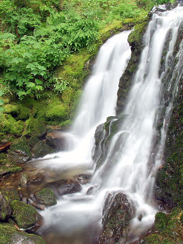
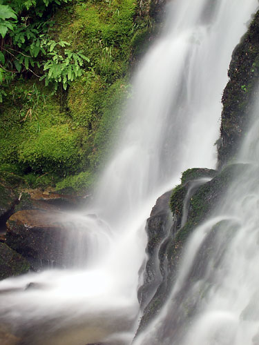
 That was when I ran into an old friend -- an unnamed waterfall that is one of the most photogenic places I have ever seen, right there on the side of the road as if begging to be photographed. I know I had shot there before, but I didn't realize it was on this road, and my recollection was that conditions weren't great last time. Aside from some intermittent wind, this time conditions were great. I had flat gray skies and the vegetation was in full summer splendor. After clearing some troublesome debris from the lower cascades, I spent over an hour shooting different compositions and scrambling up the creek.
It was hard to leave that place, but at some point you just have to say you're done. How many photos can you take of one thing anyway? For me, quite a few. I decided to make the drive up to Long Lake since I was nearby, but there were people camping there so I didn't stop. Instead I drove up to the end of the road into a very peaceful area full of trees covered in beard moss. I tried to snap a few photos, but they didn't come out. Ironically, I needed sunlight for that.
I backtracked from there and travelled up FS-5240 as I had planned, but there was nothing really of interest there. I connected to FS-52, aka Slate Creek Road, more of a highway than a Forest Service road, and headed back south. I had remembered some photogenic runoff streams along the side of the road from when I was there before, but they were all dry this time.
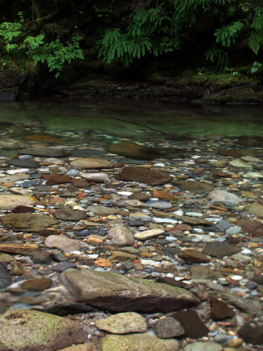 Since it was still earlier than I had planned, I took a detour up FS-5270 that follows Butter Creek. I remembered I had traveled it before, an even had some markings on my map of closed spur roads, but I didn't remember anything about it. I stopped at the first crossing of Butter Creek and immediately remembered it. After clearing a little devil's club, I walked down to the water and played around with shooting the river rocks on the bottom of the creek. This creek has a wonderful mixture of colorful rocks on its still bottom and my photos didn't do them justice.
After that I worked my way farther down the road and crossed several more creeks I distinctly remembered photographing before, in fact I think one of them had produced some nice photos. I decided to turn around there since light was fading. I'll have to check my photos to see if those before turned out. It would be well worth another trip there if not.
I have to say, it's nice to finally get some good photos in again. These are keepers, I think. And aside from the farther reaches of southern GPNF, which are tough to reach at today's gas prices, I've about covered everything there is to see on the roadside, at least that my vehicle can handle. Now that fall is near, I need to start hitting the trail again!
More photos of my old friend:

No comments:
Post a Comment